
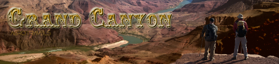
How many times we have listened to stories about how a great feeling is to look at the Grand Canyon? By looking at pictures of the canyon, you can imagine being there and have "an idea" about that feeling.
Well, if you are reading this article we can easily assume that you never went there, and if you did, we are sure that you are going to correlate to our next comment... "-There are no words nor pictures combined that can describe the overwhelming feeling of sitting on a rock, and listen in silence to the sound of the Grand Canyon"
Do you have a story to share with us? Send it to us with your pictures and we will publish it!
Leave us your comments and rate this page!. Also follow us on Facebook
Fall and Spring. Best Seasons to Go
In this trip Agrotravels visited the South Rim since North Rim was still closed due to snow and bad road conditions. The South Rim is in about 7,000 ft above sea level and it is not recommended for people with respiratory or cardiac issues (for more geographical information visit here). Also, from all the three rims (North, South and West) the South it is the most suitable to go with children since the park has excellent organization for the family to move between points up in the rim.
We do not recommend going in Summer time, particularly if you expect taking the trails going down, since as you get deeper in the canyon the hotter the temperatures are, and those may rise close to 120F (~49C). Best seasons to visit are Fall or Spring.
In this trip we made a loop visiting four Canyons located near the border lines separating Nevada, Arizona, Utah. This chapter from Agrotravels covers the first stop in our route map at mark ![]()
View Larger Map
What to do?
Hiking a section of a trail is always an option. You can hike half a trail and you will find the same humbling experience as going all the way down, with the exception that you will not see the Colorado river, of course
As an additional advice, we strongly recommend that at least one day you wake up early in the morning to see the canyon before sunrise to presence the miracle of nature at that spectacular time of the day… you will not regret it.
Precautions
If you go with kids, taking a trail that goes down in the canyon merits previous evaluation about the age and physical condition of all family members.
Travel light and take at least one gallon per person per day, comfortable hiking shoes (no tennis, nor flip flops!) and several layers of clothing to compensate the temperature variations between morning, noon, and sunset.
Driving Around
If you feel yourself identified with this picture our recommendation is DON’T DO IT. All roads, as deserted as they might look, are well patrolled and speed is checked most of the time. Arizona law makes 21 miles over the limit a criminal offense, so do yourself a favor and use the cruise control and either switch drivers or just take a rest at regular intervals. As a Sheriff Deputy said in one occasion - ”The Grand Canyon has been there for the past several million years and it will continue to be for millions of years to come. So drive safely, it will still be there even if you make it a few hours later”.
Grand Canyon National Park is a huge territory, with more than 70 miles in internal roads. We suggest you visit National Park Services website. You will find lots of relevant information about all facilities and infrastructure services offered in this monumental park.
Also you will be able to download maps, trips planner with up to date information for your joy and safety.
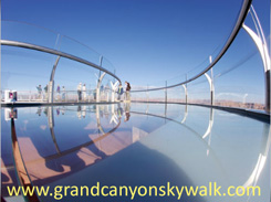
About two hours from Tusayan, and about 2 hours 45 minutes from Las Vegas, in the Hulapai Reservation there is a unique glass structure suspended at 4000 ft (1,220 mts) called the Skywalk.
This horseshoe shaped bridge gives you the impression of being suspended in the air and let you admire the dimensions and depth of the Grand Canyon from a different perspective.
The Hulapai Tribe also offers dance and singing performances as well as native artistry and jewelry.
